


Yosemite Looksee AR app for iPhone and iPad
Developer: Objexs Limited
First release : 27 Jul 2017
App size: 18.39 Mb
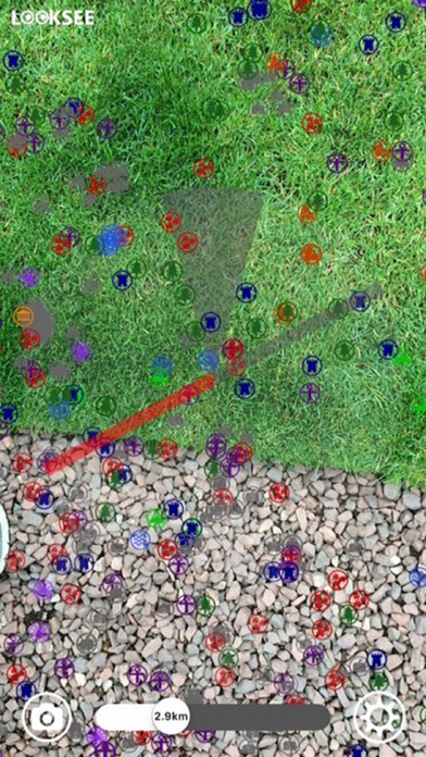
Looksee is an augmented reality navigator used to find places of interest directly within your cameras view and add fun, knowledge and interest to your adventures and tours.
Its simple to use - you just point and go! It includes a choice of Map or Satellite Image in view and a Search function to help locate things.
Once downloaded no wi-fi or cellular network is necessary, so you can use when out and about when there is no or poor signal coverage.
This version is for Yosemite and locates places within the National Park and beyond into the wider California and Nevada areas. The area covered encompasses a rectangle stretching north past Black Hawk Mountain in Tuolumne County, east past Mount Dana into Nevada, South past the town of Wawona and west to Merced. This is an area of over 3,000 sq miles (7,000 km2).
All towns and districts within the region are covered including: Curry Village, El Portal, Fish Camp, Foresta, Groveland, Mariposa, Merced, Midpines, Tuolmne, Wawona and Yosemite Village.
In fact there are around 10,000 places of interest viewable within the App including places such as the Tunnel View, El Capitan, Sentinel Dome, Half Dome, Bass Lake, Lake Eleanor, Bridalveil and Ribbon Falls.
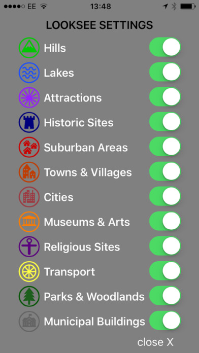
Categories that can be viewed and selected include Tourist Attractions, Hills, Lakes, Parks & Woodlands, Cities, Towns, Suburban Areas, Villages & Hamlets, Cafes, Restaurants, Cafes, Airports, Train & Major Bus Stations, Municipal Buildings, Places of Worship, Historic Sites and Museums & Arts.
Some of the helpful Looksee features include:
- Interactive objects (that you can touch for more information on them)
- Magic EYE (to declutter the visuals and select only objects within)
- Satellite or Map image in view (can select which or disable completely)
- Search menu (with on-screen directional arrow and indicator graphics)
- Filters menu (using which the categories of points of interest you wish to display can be easily filtered out or selected)
- Distance slider (for an interactive depth of view filter up to 10km)
- Zoom (using an on screen pinch to zoom gesture)
- Snap-shot camera (for annotating your photos)
- Video recorder for saving and sharing interesting places on social media (accessed by holding the camera icon for 1 second)
- Radar view of everything around you on map (hold face down)
So please enjoy adding interest to your outdoor adventures!